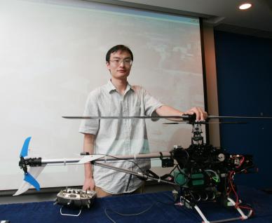
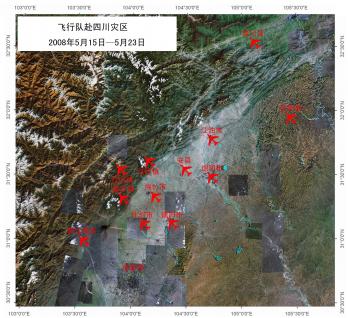
An unmanned model helicopter developed by a postgraduate student at the Hong Kong University of Science and Technology (HKUST) conducted an aerial scanning of the landscape and facilities affected by the recent Sichuan Earthquake to help the authorities assess the damage and plan recovery.
The helicopter, installed with a video camera, is linked to the Global Positioning System (GPS) and can fly on its own on a preset course. It differs from a remote-controlled model helicopter in that a remote-controlled one has to be controlled at all times while air-borne, and has to stay within the line of sight of the ground control. On the other hand, the unmanned automated helicopter can fly on its own beyond the line of sight of the controller, and its flight range is limited only by the amount of fuel it carries.
The helicopter was deployed in Sichuan on 15 May, only three days after the earthquake hit the province, and in the following nine days, it took aerial photos of 12 affected cities, towns and counties.
“The aerial scanning provides immense help to rescue and recovery operations. It helps the working teams to assess the damage, set priorities, and helped chart the course of action,” said Mr Wang Tao, who developed the unmanned automated helicopter. Mr Wang is currently an MPhil student of Professor Li Zexiang in the Department of Electronic and Computer Engineering of the Hong Kong University of Science and Technology.
Mr Wang has a company in Shenzhen that provides unmanned automated helicopter services to clients. One of his clients – an electronic map company in Guangdong, recommended Mr Wang to the Sichuan authorities.
“There are numerous benefits in using an unmanned automated helicopter to take aerial photos of disaster sites. First, it is fast, as the helicopter can reach the required location within minutes – where it would take people many hours and even days to reach if the terrain is unfriendly. Second, it is safe, because there is no need for people to travel over disaster-stricken routes, which are often treacherous. Third, it is much cheaper than flying real helicopters to carry out reconnaissance,” said Mr Wang.
While the unmanned helicopter looks similar to a remote-controlled model helicopter, it is a much more sophisticated and smart flying machine. Its real time monitoring function enables the controller to continuously view the images. Navigation is controlled by a preset program and GPS-assisted. It is also equipped with air speed sensors that produce signals for the controls to counteract the force of wind, enabling the helicopter to fly in the desired direction or remain steady in one position.
“The control console is the brain of this unmanned automated vehicle,” said Mr Wang. “It can be set to control not only helicopters, but fixed wing aircraft.”
“These unmanned automated vehicles are versatile and can have scientific, commercial and even military applications. My target is to develop more of these vehicles and make them affordable to more users,” he added.
For media enquiries, please feel free to contact :
Ross Lai
Tel: 2358 6306 / 9103 2928
Email: rosslai@ust.hk
Donna Wong
Tel: 2358 6317
Email: donnaw@ust.hk


